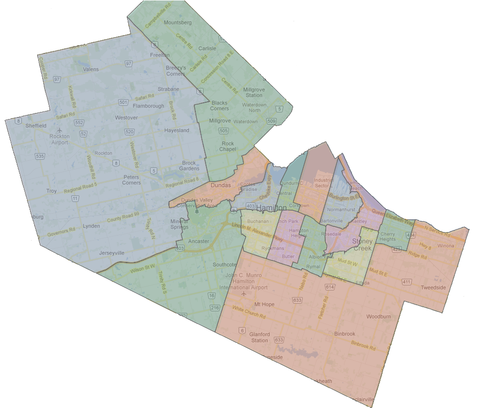
(This is a bit of a long read; I started with the thought of writing about the localism of East Hamilton and where exactly East Hamilton starts. It became this 2500-word piece on Hamilton’s localisms city-wide and how I see them. I hope you enjoy and share your feelings – especially the strong ones – below)

As a Hamiltonian, I’m often surprised when Barton Street and Sanford Avenue is called “north end”, City staff use “north end” to describe the industrial sector between Sherman Avenue and Woodward Avenue, apartment buildings along Queenston Road in Stoney Creek are “east end,” the stadium is “east end,” Westdale is called Hamilton’s “west end,” Parkdale Avenue and Queenston Road is called “Stoney Creek”.
Hamilton is a large amalgamated city, no longer just the old City of Hamilton. This is why even the terminology used for the lower city is being forced to change.
Arguably, the entire lower city is now “North Hamilton,” especially with the rapid expansion of Hamilton south since the opening of the Lincoln Alexander Parkway, growth in Upper Stoney Creek and Glanbrook, and the inclusion of agricultural lands to the south of the urban boundary.
As a local journalist who is a Hamiltonian, I have strong opinions on when these terms should be used.
People who live in these communities – especially those along boundaries that are not exactly clear and even when they boundaries are clear – have stronger opinions still.
Those opinions will differ from mine and official political boundaries.
What do these terms mean? What are the hidden and not-so-hidden meanings?
North End

North End is most often used to indicate – second hand – that a neighbourhood is poor or crime-ridden. It’s usually dropped when referring to Hamilton’s true North End in a positive story.
When writing about the booming real estate in the neighbourhood geographically defined as the North End (North of the CN mainline, west of Wellington), the term Hamilton’s waterfront is often used to clarify the use of North End for geographical purposes.
This second-hand negative meaning is why Barton and Sanford is “north end” in a crime story or “north end” to refer to Jimmy Thompson pool within the context of the area being a lower-income neighbourhood.
City staff will refer to pollution in Hamilton’s north end, or poverty in Hamilton’s north end when referring to neighbourhoods well outside of the traditional north end – even when the term was used commonly to refer to all residential areas north of the CN mainline tracks.
Those who grew up in the north end and found successful careers use the term to denote the adversity they’ve overcome and the character built growing up in a poor community where personal honour was the most important currency, since money was hard to come across.
I now use North End to refer solely to the neighbourhood or for historical context for someone who grew up north of the CN mainline and west of Lottridge. (From my own experience growing up, I see the area along Beach Road to be very different from the Keith neighbourhood of Wentworth North.)
East End and East Hamilton

East End is an interesting term to define geographically and for social meaning.
Personally, I’ve decreased my use of the term in favour of using neighbourhood names, key landmarks, and intersections to place a story in East Hamilton.
To me, East End refers to the former “blue collar” culture of an area where steelworkers lived closer to the factory, which provided plentiful good employment, and the strong union culture that came from those neighbourhoods.
That culture is no longer homogeneous in any East Hamilton neighbourhood, and today’s East Hamilton neighbourhood cultures are guided more by recent waves of new Hamiltonians from the 905 and Toronto than social class.
I use “East Hamilton” for stories east of Gage Avenue, but mostly past Ottawa Street. I personally feel that Ottawa Street belongs to both East and Central Hamilton.
Ottawa Street also serves as the boundary between Wards 3 and 4, but I’ve never found ward boundaries to be useful for splitting geography in the Lower City.
Hamilton Police have a divisional boundary at Sherman Avenue, causing incidents at Sherman sometimes to be called East End.
I can’t quite define “East End” in my mind.
I could during my childhood when there was greenfield on the Hamilton side of the Stoney Creek border. Now, Hamilton and Stoney Creek’s border is a paper boundary for the most part. (More on this boundary below)
If there is an “East End”, surely its the area east of the Red Hill Valley?
However, I don’t hear people living north of Queenston Road from the Valley to Centennial Parkway (which I still call “Highway 20”) refer to themselves as “East End”.
South of Queenston, they don’t either.
South of King, the “Davis Creek” name is taking hold among those who identify with Hamilton and other parts of East Hamilton here identify themselves with Stoney Creek.
East of Highway 20, there is Riverdale. This neighbourhood is clear in its identity as Riverdale.
There is no area which I can clearly identify as “East End” today.
Hamilton East – Stoney Creek Boundary
What is the east boundary of East Hamilton, and when does it become Stoney Creek?
This is my favourite boundary because of how the political boundary is not disputed, but the localisms are.
I ran in Ward 5 for School Board Trustee in 2000, and this was the first time I realized just how strongly some residents feel about an affinity towards Stoney Creek – despite officially living in Hamilton.
The delivery area of The Stoney Creek News offers a good boundary for those living within the political boundary of Hamilton who identify as being in Stoney Creek.
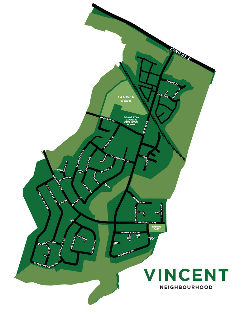
When I went door-to-door during the 2000 election, people living east of Quigley Road and south of Greenhill Avenue in the Vincent neighbourhood tended to lean towards saying they lived in Stoney Creek. (see map below)

The developments east of Greenhill in the Gershome neighbourhood are mostly post-2000 era construction. (The last of that gap between East Hamilton and Stoney Creek that I knew growing up)
The homes that were in Gershome when I ran in 2000 identified more with Stoney Creek than Hamilton from my subjective experience.
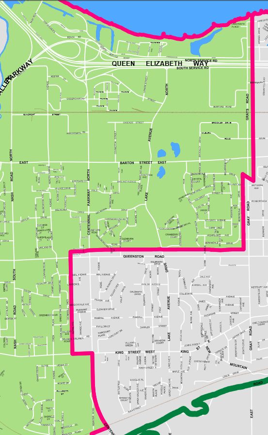
Many of my friends from Glendale Secondary School lived east of Nash Road between Queenston and King. All of them identified with Hamilton.
Going door to door, I didn’t encounter many people in that neighbourhood referring to themselves as being part of Stoney Creek.
I wonder if, like the homes north of Queenston, this is because they are well connected by transit to Hamilton proper, and most of the homes were built a few decades ago.
Riverdale

Riverdale is interesting because the boundary between Hamilton and Stoney Creek isn’t Queenston Road itself. Instead, it runs along an old survey line just north of the street.
All the apartment buildings and businesses on the north side of Queenston are in Stoney Creek. (9 Riverdale Drive is also in Stoney Creek on the northwest corner of Queenston and Riverdale)
Everything else north of Queenston Road is in Hamilton’s Riverdale neighbourhood.
I find that the residents of detached homes in Riverdale—especially those east of the Stoney Creek waterway—identify with Stoney Creek.
Residents of the apartment buildings along Queenston Road west of the waterway lean towards identifying with Hamilton.
This may be partly explained because street addresses along Queenston Road in Stoney Creek continue their numbering from Hamilton side
There is fierce pride in Riverdale as an identity among the apartment buildings south of Barton Street and west of Lake Avenue.

I write Riverdale for the apartment buildings within Hamilton, I describe the apartment buildings as being in Stoney Creek near Eastgate Square, and the detached homes as “in Riverdale along the Stoney Creek border.”
Eastgate Square is almost always referred to as being in Stoney Creek. Except for a sliver of the parking lot at Centennial and Queenston, the entire mall is on the Hamilton side of the boundary. The mall self-identifies as Stoney Creek.
Upper Stoney Creek vs. Stoney Creek Mountain

Another interesting localism is the naming of the portions of Stoney Creek above the escarpment.
Is it Upper Stoney Creek or Stoney Creek Mountain?
Growing up, I always heard it referred to Upper Stoney Creek. Its neighbourhoods as Valley Park or Satellite City.
I never heard Stoney Creek Mountain.
A Google search of the City of Hamilton website shows a fairly even divide between the two terms with 79 results for “Upper Stoney Creek” and 61 results for “Stoney Creek Mountain”.
Over at TheSpec we find 517 results for “Upper Stoney Creek” and only 59 results for “Stoney Creek Mountain”.
A search of the Stoney Creek News finds 365 results for “Upper Stoney Creek” and only 29 results for “Stoney Creek Mountain”
Most of the “Stoney Creek Mountain” usages are more recent, indicating a possible change in terminology that could be reflective of the increased inflow of new Hamiltonians or the direct connection of Upper Stoney Creek to Hamilton Mountain following growth that came with completion of the Red Hill Valley Parkway.
A search of the Hamilton Spectator archives going back to 1991 finds 538 results for “Upper Stoney Creek” and 266 for “Stoney Creek Mountain”.
I’m sticking with Upper Stoney Creek for now, but accept our localisms change.
I expect Stoney Creek Mountain will become dominant, especially with growth in Binbrook creating more of an east-west flow of people on the escarpment compared to the past when residents of Upper Stoney Creek had to travel down Highway 20 to Eastgate for shopping and services.
Hamilton Mountain Neighbourhoods
Hamilton Mountain is interesting to cover for me as I lived on the Mountain when nearly everything south of Limeridge Road was active farmland. There were farms north of Limeridge Road to the east of Upper Ottawa as well in the early 1990s.

Today, the Mountain is fully developed with the exception of a few pockets in Ward 8 south of Stone Church Road. Stone Church Road and Rymal Road are both busy arteries and traffic on the Mountain seems much busier to me than the Lower City.
What are the neighbourhoods of the Hamilton Mountain?
I tend to use the divide the Mountain by east, central, and west using the ward boundaries with Ward 6 being east, Ward 7 being central, and Ward 8 being west.
Within Ward 6, I use the Linc, Kenilworth Access, and Mohawk Sports Park as key landmarks. As Mountain streets are on a grid pattern, I’ll almost always note the nearest major intersection.
For Ward 7, the Linc and Limeridge Mall are major landmarks. Stories in the Concession Business Improvement Area are noted as being there. I’ve seen Concession referred to as the North Mountain. I find the term confusing and don’t use it. Major intersections are noted in most stories.
Ward 8 has the Linc and Mohawk College. Major intersections are noted in most stories.
Lower City West of Downtown
I’m just going to say it, I can’t stand the term “West End” that is sometimes used in local media. There’s Westdale, West Hamilton, Ainslie Wood.
West of the Downtown, I use the neighbourhood names for Strathcona and Kirkendall. Both have strong neighbourhood identities.
West of the 403, it’s either Westdale, Ainslie Wood, Main West for the stretch of multi-res buildings approaching Wilson Street, and McMaster for the campus itself.
Dundas

I lived in Dundas for a year, in University Gardens.
For terminology, I’ll note University Gardens, Pleasant Valley, and Downtown Dundas as neighbourhoods. Otherwise, I’m noting location by citing the nearest major street such as Governors Rd, Syderham Rd, York Rd, or King St.
Stoney Creek and Winona
Downtown Stoney Creek, Upper Stoney Creek, and Valley Park are my choices for the older parts of Stoney Creek. For lower Stoney Creek, I tend to use the nearest major north-south road as the landmark.
Winona, of course, gets referred to as Winona. This is all of Stoney Creek east of Lewis Road.
I don’t wish to be barred from the Peach Festival for daring to call it East Stoney Creek. Long-time Winona residents often remind me how they fought against amalgamation with the Town of Stoney Creek in the 1970s. (Don’t ask them what they think of the 2000 amalgamation)
Tapleytown in Upper Stoney Creek is referred to as such, with a description of its location.
Glanbrook, Binbrook, and Mount Hope
Here’s a question I haven’t answered, where does Binbrook end and Glanbrook begin?
With the rapid growth of the Binbrook urban area, this question has become harder to answer. Officially, Glanbrook is the agricultural area of the area south of Hamilton and Stoney Creek.
Substantial areas of this farm land is zoned within the urban boundary expansion.
For purposes of my stories, I’ll use Binbrook for the existing urban area, and proposed developments.
Mount Hope is clearly defined.
For the reminder of Glanbrook, I’ll use reference points such as Highway 6, major intersections, and proximity to Binbrook and Mount Hope to describe location.
Ancaster
I use the Ancaster Meadowlands for the newer parts of Ancaster east of the 403, Old Ancaster for the downtown area of Old Ancaster.
Major intersections are used for other areas of Ancaster.
Alberton, Carluke, and Jerseyville are referred to by their community names in stories, reflecting their continuing unique identities. Duff’s Corner’s remains a historical landmark at the intersection of the former Highways 2 and 52.
Flamborough
Flamborough is many communities: Carlisle, Copetown, Freelton, Greensville, Lynden, Millgrove, Rockton, Sheffield, and Waterdown.
There are official boundaries for each of these communities.
Generally, I’ll use the community that individuals in my stories self-identify with. Someone may be just outside of the boundaries of a rural settlement, but still identify with it.
I’ll use major intersections to try to place stories.
Your Localisms?
I’m put out my view of Hamilton’s localism. I’m sure many of yours may differ.
I’m especially interested in what your thoughts are for local boundaries in the former municipalities.
Thanks for reading.
